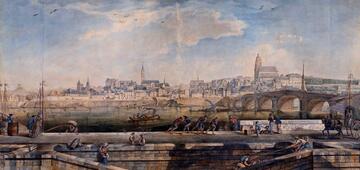
The Loiret river, on the outskirts of the Orléans urban area, boasts a remarkable, highly appealing built and natural heritage for visitors. The ASPL association has updated and republished a map of this heritage with technical assistance from the Loiret Canoe-Kayak County Board and nature reserve Saint-Pryvé-Saint-Mesmin, and thanks to funding from the Centre Region, Orléans urban area and European funds.
The Loiret is at once a living environment – since a major stretch of the river is private (residents are grouped together in a union) – an area for walking, relaxing and leisure activities (fishing, cycling, canoeing, rowing, etc.), as well as a fragile nature spot, particularly at its mouth with the Loire: the Courpain point, since the site is listed as a nature reserve. Last but not least, it is worth noting that the river banks also showcase a remarkable built heritage: châteaux, prestigious residences, boat stations, mills, open-air cafés with dancing and restaurants along the water's edge (the whole length of the river is included in an Architectural, Urban and Landscape Heritage Protection Zone (ZPPAUP), and within the stretch of the Loire Valley listed as a UNESCO World Heritage).
A new edition of this map has been published in 2012 to limit these conflicts of use and distribute visitor crowds evenly along the Loiret. The previous version of this map is no longer valid. The APSL has therefore updated it and added a few notions such as the location of boarding and alighting points for canoes.
The Loiret river map is available free of charge from the APSL: just ask!
Online:


![Nouvelles Renaissance(s] 2023](/var/storage/images/val-de-loire-refonte/dossier-de-parametrage/pied-de-page/nouvelles-renaissance-s-2023/517479-13-fre-FR/Nouvelles-Renaissance-s-2023_image_largeur220.png)